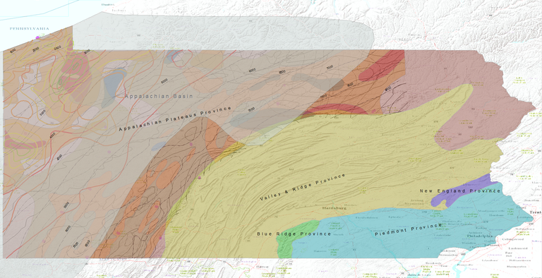
AAPG Datapages and the AAPG GIS Publications Committee wish to thank Katharine Lee Avary, the Department of Energy’s Eastern Gas Shales Project (EGSP), the United States Geological Survey (USGS) and the AAPGF-OSU Geoscience GIS Consortium for allowing the Devonian Shales of the Appalachian Basin GIS Dataset to be posted on Datapages’ GIS Open Files page, thereby making it available to the public as a free download.
INTRODUCTION
A large body of literature generated during the late 1970's and early 1980's, primarily through the United States Department of Energy's Eastern Gas Shales Project (EGSP), is very valuable in providing a stratigraphic, geochemical and structural framework for the Devonian shales in the Appalachian Basin, including the Marcellus Shale. Maps from several EGSP summary reports (Schweitering, 1981; Tetra Tech, 1981a; Tetra Tech, 1981b; Tetra Tech, 1981c) as well as those from United States Geological Survey Bulletin 1909 (Roen and Kepferle, 1993) were digitized for use in ArcGIS. Much of the work published in Bulletin 1909 is an outgrowth of research conducted during the EGSP as well as some newer work funded by the Gas Research Institute (currently the Gas Technology Institute).
Other maps from the chapters within the Atlas of Major Appalachian Gas Plays (Boswell, 1995; Milici, 1995; Roen and Walker, 1995) which deal with Devonian shales and more recent U.S. Geological Survey Devonian vitrinite reflectance (Ro) and conodont alteration indices (CAI) maps (Repetski and others, 2008) are also included in this dataset. The most recent USGS Ordovician CAI map (Repetski and others, 2008) was also added to this project, given current interest in the Ordovician Utica Shale. In addition, chapters in Bulletin 1909 focus on the Antrim Shale in the Michigan Basin, the New Albany Shale in the Illinois Basin and the Kettle Point Shale in Ontario.
These publications and resulting GIS datasets provide a fundamental framework for oil and gas exploration in the Devonian shales of the Appalachian Basin.
REFERENCES AND GIS DATA DOWNLOADS
Boswell, Ray, 1995, Play UDs: Upper Devonian black shales: in: Roen, John B., and Brian J. Walker, eds., The atlas of major Appalachian gas plays, West Virginia Geological and Economic Survey, Volume V-25, p. 93-99.
GIS DATASET – Refer to Roen and Walker to download the GIS dataset
Milici, Robert C., 1995, Play Dbg: Upper Devonian fractured black and gray shales and siltstones: in: Roen, John B., and Brian J. Walker, eds., The atlas of major Appalachian gas plays, West Virginia Geological and Economic Survey, Volume V-25, p. 86-92.
GIS DATASET – Refer to Roen and Walker to download the GIS dataset
Repetski, John E., Robert T. Ryder, Anita G. Harris and Michael H. Trippi, 2008, Thermal maturity patterns (CAI and %Ro) in Upper Ordovician and Devonian rocks of the Appalachian Basin: A major revision of USGS Map I-917-E using new subsurface collections: United States Geological Survey, Scientific Investigations Map 3006, 26 p., 11 fig., http://pubs.er.usgs.gov/publication/sim3006
LINK TO GIS DATASET
Roen, John B., and Roy C. Kepferle, 1993, editors, Petroleum geology of the Devonian and Mississippian black shale of eastern North America: United States Geological Survey, Bulletin 1909, Chapters A-N., http://pubs.er.usgs.gov/publication/b1909
LINK TO GIS DATASET
Roen, John B., and Brian J. Walker, eds., 1995, The atlas of major Appalachian gas plays: West Virginia Geological and Economic Survey, Volume V-25, 201 p.
LINK TO GIS DATASET
Schweitering, Joseph, F, 1981, The occurrence of oil and gas in Devonian shales and equivalents in West Virginia: U.S. Department of Energy, Report DOE/ET/12130-113, 38 p., 18 plates, http://www.netl.doe.gov/kmd/cds/disk7/disk1/EGS%5CThe%20Occurrence%20of%20Oil%20and%20Gas%20in%20Devonian%20Shales%20and%20Equival.pdf
LINK TO GIS DATASET
Tetra Tech, Inc. 1981a, Evaluation of Devonian shale potential in New York: U.S. Department of Energy, Morgantown Energy Technology Center, Report DOE/METC-118, 20 p.
LINK TO GIS DATASET
Tetra Tech, Inc., 1981b, Evaluation of Devonian shale potential in Ohio: U.S. Department of Energy, Morgantown Energy Technology Center, Report DOE/METC-122, 61 p., http://www.netl.doe.gov/kmd/cds/disk7/disk1/EGS%5CEvaluation%20of%20Devonian%20Shale%20Production%20in%20Ohio.pdf
LINK TO GIS DATASET
Tetra Tech, Inc., 1981c, Evaluation of Devonian shale potential in Pennsylvania: U.S. Department of Energy, Morgantown Energy Technology Center, Report DOE/METC-119, 75 p., http://www.netl.doe.gov/kmd/cds/disk7/disk1/EGS%5CEvaluation%20of%20Devonian%20Shale%20Potential%20in%20Pennsylvania.pdf
LINK TO GIS DATASET